Sunday 17 November 2013

Climate Choke Point East of Greenland


The Arctic Ocean has an important role in Earth’s climate. The Arctic is part of the globe that is most sensitive to climate change. The choke point for the Arctic Ocean is the Fram Strait.  Currently the Arctic is shifting to a new normal; sea-ice is thinning, permafrost is thawing, and tundra is greening [1]. 

Arctic sea ice minimum 2012 compared to 30 average minimum [a]
The extend of its summertime sea-ice cover determines how much sun-light is reflected back into space. The Arctic receives important freshwater inflow from North American and Siberian rivers. Sea ice is export through the Fram Strait into the North Atlantic and is freshening the most salty ocean of the globe. The Frame Strait between Greenland and Svalbard is the only deep passage linking the Arctic Ocean to the global ocean. The main export vein of deep Arctic waters goes through this strait. Deep Arctic waters are forming in the interior of the Arctic ocean basin.

Freezing and cooling produce deep water in the Arctic ocean. Only if it is exported at depth out of the Arctic Ocean, then it is contributing to the global thermohaline circulation. The thermohaline circulation of the oceans is the slow vertical overturning of its water that brings heat and oxygen into the depth of the world ocean. One of the drivers of this circulation is the deep, cold and salty water that is flowing through the Fram Strait out in depth from the Arctic Ocean. To understand climate change processes it has to be assessed how the outflow of deep water from the Arctic Ocean varied during last several ten-thousand years.
Flow through Fram Strait - top/in & bottom/out [b]
Did the Arctic Ocean export waters through cold and warm climates, or did this export shut-off in warmer climates? Ratios of the radionuclides thorium-230 (230Th) and protactinium-231 (231Pa) in the sediments at the sea-bottom can be used to assess this question [2].

These radioactive tracers are produced in sea water by radioactive decay of natural uranium, which is transported by the rivers into the sea. Thorium and protactinium are not soluble in seawater and attach in a different time-depending manner to particles made of different minerals. These particles drop to the sea bottom and so remove the radioactive traces from the water column. This process is called “scavenging”. The “scavenging” of thorium and protactinium happens with a different speed. Much of the thorium will drop to the bottom even if much deep water is flowing out of the Arctic ocean. However an important part of the protactinium would be swept out through the Fram Strait if the outflow of Arctic waters is happening. Thus, the thorium and protactinium concentrations in sediments of the Arctic Ocean vary with the strength of the outflow of deep water through the Fram Strait. Whether that outflow varied during glacial, de-glacial and interglacial conditions can be studied in sediment cores taken from the bottom of the Arctic Ocean.

Thorium [c]
It has been found that the measured thorium burial is in balance with its production in Arctic seawater but that, for all time intervals, the burial of protactinium is in deficit. Thus, protactinium has been exported out of the Arctic Ocean all time throughout the past 35,000 years [2]. The outflow has to have been so strong that the replacement time for deep waters in the Arctic Ocean is many centuries since the most recent glaciation. Thus, Arctic waters are a persistent contribution to the global ocean circulation throughout the end of the last glacial periode and the following warmer Holocene.

Martin.Mundusmaris@gmail.com
info@mundusmaris.org

 
[1] M. O. Jeffries, J.E: Overland and D.K. Perovich, 2013. The Arctic shifts to a new normal, Physics Today, Vol 66(10)
[2] Sharon S. Hoffmann, Jerry F. McManus, William B. Curry & L. Susan Brown-Leger, 2013, Persistent export of 231Pa from the deep central Arctic Ocean over the past 35,000 years
Nature 497, 603–606, http://www.nature.com/nature/journal/v497/n7451/full/nature12145.html

[a] from:http://www.nasa.gov/topics/earth/features/2012-seaicemin.html 
[b] from: http://www.arcticsystem.no/en/outsideworld/oceancurrents/
[c] from: http://www.larrymylesreports.com/thorium.htm


Sunday 26 May 2013

Keeping the heat on, or powering Europe!

 Moving on to Toronto, Florence, Vladivostok or Seattle?

Toronto, Florence, Vladivostok and Seattle are particular cities with particular surroundings. All four cities are situated about half way between the Equator and the North-pole, but what for a different climate they offer! Definitely, it's not the same choice where to live. 

Toronto Skyline
(from: http://www.intelligenthq.com/world/
top-ten-cities-to-live-and-work-in-2012/)
This four cities are situated at about the same northern latitude. Toronto in eastern Canada is facing the cold western North Atlantic Ocean.  
Florence in Europe is facing the warm eastern North Atlantic Ocean. Vladivostok in the far east of Russia is situated at the cold western shores of the Pacific Ocean, and Seattle at its  warm eastern shores.

Florence and Seattle have warm summers and temperate winters. Toronto and Vladivostok have temperate summers and really cold winters. Florence has the most clement climate, followed by Seattle, Vladivostok coming well last. 

Florence annual mean day-time temperature is 20°C, and its annual mean night-time temperature is 9°C. For Seattle the annual mean temperatures are 15°C and 7°C, respectively.  Toronto has an annual mean day-time temperature of 13°C, and its annual mean night-time temperature is 5°C. In Vladivostok the annual mean day-time and night-time temperatures are 9°C and 2°C, respectively.  

The average day in Vladivostok is as warm as the average night in Florence!

Watch your neighbouring ocean

These differences of the local climate of  Toronto, Florence, Vladivostok or  Seattle are strongly determined by the temperature of the surface waters of their neighbouring ocean. The  surface waters at northern east-coast of the North-Atlantic Ocean are much warmer than surface waters as its northern west-coast. The same pattern is found in the North-Pacific; the northern east-coast of  North Pacific is much warmer than its northern west-coast. The cross-ocean temperature difference is more pronounced in the North Atlantic Ocean than in the North Pacific Ocean. 

Florence -  Arno River
(from: http://www.saiprograms.com/news/
student-blogger-amanda-florence-fall-2012)
Lucky Europe, is heated by the currents of the North Atlantic Ocean!  Not so lucky Japan, its northern islands are cooled by the Pacific Ocean but happily Japan's southern islands are swept by the warm Kurishio. The currents of the Kurishio does for the North Pacific Ocean and North America what the Gulf Stream does for the North Atlantic and Europe; warm surface waters are pushed north-eastward across the ocean. 

Kurishio and Gulf Stream are part of a much wider pattern of  variable global currents and related fluctuating transport of heat, salt [1] and other substances.

A kind of global 'conveyor belt'  links the oceans at the top and at the bottom, with surface currents transporting warm water northward to the Arctic while cold water in the depths flows back to the tropics and around the world. But that belt operates with "stop and go", with the strength of currents varying widely from year to year, decade to decade.  

This circulation, in the North Atlantic called the 'Atlantic Meridional Overturning Circulation' ferries vast amounts of heat from the tropics to northern latitudes [2]. One of its main components is the Gulf Stream. But far more is happening below the surface in the depth of the ocean that determines features and variable strength of  currents and related heat transport [3]. The 'Atlantic Meridional Overturning Circulation' forms the part of the global  'conveyor belt' that operates in the North Atlantic Ocean.

Warm conveyor belt waters from Cape Hatteras to Murmansk

Global Conveyor Belt
(from: http://www.ucsusa.org/global_warming/
science_and_impacts/science/abrupt-climate-change.html)
The Gulf Stream transports heat along the eastern shores of North America up to Cape Hatteras and than into the wider North Atlantic Ocean setting of as the North Atlantic Current. The warm surface water moves across the North Atlantic Ocean to Europe and up into the Greenland Sea between Norway and Greenland. There part of the warm water is cooled and sinks into the depth, and part moves further north into the Arctic Ocean keeping the very northern European ports (at 69° N) ice-free. So regular cargo-ships can sail to Kirkenes and Murmansk at latitudes where elsewhere at similar latitude only icebreakers may navigate the ocean. The warm sea heats the western winds that keep Europe's climate mild. Nowhere else in the northern hemisphere is the climate so clement at the same northern latitudes.

The North Atlantic Ocean is the powerhouse heating Europe.

Conveyor Belt in the North Atlantic Ocean
(from:http://www.sonoma.edu/users/f/freidel/
global/207lec2images.htm )
Year-to-year and longer term changes in the strength of the  'Atlantic Meridional Overturning Circulation' happen and likely are affecting seasonal wetter conditions across Europe, Africa and the Americas.

For example, observations from 2009 indicate that strength of the overturning circulation dropped by 30% for a year. This reduced the amount of heat transported to the North Atlantic by almost 200 trillion watts. That drop of heat transport into the North Atlantic ocean has been linked to the harsh winters in Europe 2009-10 [4]. 

The estimate drop of heat transport is only a minor part of the total heat transport around the globe by ocean currents, nevertheless  200 trillion watts  is a tremendous amount of heat. This amount of heat corresponds to about half of  the additional amount of heat that currently  is captured by the atmosphere because of the increased carbon dioxide concentration of the atmosphere;  increase beyond the pre-industrial values of 290 ppm currently we hit the 400 ppm [ppm = parts per million]. A fluctuating heat tarnsport of that size is important. Therefore detailed and lasting observation along transects of the entire Atlantic Ocean are planned for the next years [4].

Between Greenland and Caribbean Seas

Cape Hatteras 
(from: http://soundwaves.usgs.gov/2009/04/fieldwork3.html)
A key element of the conveyor belt is found in the the Greenland Sea and the Labrador Sea. When reaching this region in the north-eastern North Atlantic Ocean the warm surface waters cool and sink; sink really deep down to the bottom of the sea [5]. In that cooling process heat is passed on to the atmosphere and carbon dioxide is carried to the depths, sequestering it from the atmosphere.  Winds move warmed air eastward into Europe.

Water in the depth is moving back towards the equator along the continental slopes of Greenland and North America. Thus a cold southward current runs in the depth of the ocean along the North American east cost. The deep current is  accompanied by cold surface waters, the Labrador current, that sweeps the shores of Canada and north-eastern states of the USA before - south of Cape Hatteras - the warm northward flowing Gulf Stream dominates the surface currents. Thus, the east-coast of North America is cooled in the north and heated in the south. However, in the depth all along  the continental slope a mighty vein of cold water runs southward, the back-loop of the 'conveyor belt' in the North Atlantic.

The cold water that was formed in European sup-polar seas moves south into the South Atlantic Ocean where waters from different sources meet, including water from the Indian Ocean and the Pacific Ocean. The South Atlantic Ocean has its own less vigorous overturning circulation. It is moving heat along the shores of South America from the tropics poleward linking into the mighty circumpolar current sweeping around the Antarctic continent. Likewise - as a key part of the global 'conveyor belt' -  heat is swept  by surface currents northward out of the tropical South Atlantic Ocean. Warm water flows into the western tropical North Atlantic Ocean and the Caribbean Sea from where after further heating the even warmer water is shifted forward to Europe.

(from: http://www.why.is/svar.php?id=5470)
"What would happen if the North Atlantic Current
should stop or change direction?"...
 ....compare climate in Labrador and Ireland. 
The net global oceanic heat transport is into the North Atlantic where the heat is released from the ocean into the atmosphere. This heat then is swept by the winds into Europe, Northern Africa and Asia.

The relative warm surface waters of the North Atlantic Ocean, which are already enriched in salt content for example by the outflow of salty water from the Mediterranean, pass humidity to the warm atmosphere. The surface waters get saltier than surface waters of any other ocean. This high salt content is a favourable precondition for the deep-water formation in  Greenland Sea and Labrador Sea, what in turn is engine moving around the 'conveyor belt'. That engine drives the North Atlantic powerhouse for keeping Europe's climate warm and clement.


Martin.Mundusmaris@gmail.com
info@mundusmaris.org

[1] See related posts: 
  • http://martinmundusmaris.blogspot.de/2013/02/change-pitch-with-pinch-of-salt.html,
  • http://martinmundusmaris.blogspot.de/2012/04/giant-swirls-tiny-swirls-dancing-sea.html
[2] The similar feature does not occur in the Pacific Ocean with the same strength because the Bering Sea linking it with the Arctic Ocean is shallow and the salt content of the surface waters of the Pacific Ocean is lower. However the winter freezing of Okhotsk Sea causes formation of a modest volume of deep water.

[3] McCarthy, G. et al. (2012), Observed interannual variability of the Atlantic meridional overturning circulation at 26.5°N, Geophysical Research Letters: "The Atlantic meridional overturning circulation (MOC) plays a critical role in the climate system and is responsible for much of the heat transported by the ocean. A mooring array, ...  provides continuous measurements of the strength and variability of this circulation. With seven full years of measurements, we now examine the interannual variability of the MOC. While earlier results highlighted substantial seasonal and shorter timescale variability,... From 1 April 2009 to 31 March 2010, the annually averaged MOC strength was just 12.8 Sv[erdrup = 1.000.000 m³ / second], representing a 30% decline. This downturn persisted from early 2009 to mid-2010....  This rebalancing of the transport from the deep overturning to the upper gyre has implications for the heat transported by the Atlantic."

[4] Q. Schiermeier, Ocean under surveillance, Nature, Vol. 497 p.167-168. The article by Q. Schiermeier has motivated me to prepare this contribution for my blog "Mundus Maris... first news". 

[5] Rudels, B. Quadfasel D. (1991), Convection and deep water formation in the Arctic Ocean-Greenland Sea System, Journal of Marine Systems: "The processes of convection and deep water formation in the Nordic Seas.... The dense shelf waters sink on the continental slopes into the deep basins entraining ambient waters from the strongly stratified Arctic Ocean proper. In the European Polar Seas—the Nordic Seas—deep water is only formed in the Greenland Sea through haline convection, ...resulting in a weakly stratified water column...".


Saturday 23 March 2013

Marine Heavens on Snowball Earth ?

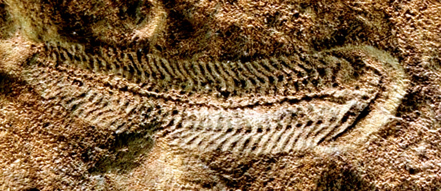
Spriggina is an Ediacaran organism, possibly it is an animal.
 Spriggina grew to about three centimetres, it was segmented,
with one row of tough plates on top and two interlocking
rows on the bottom, and it may have been predatory.
(from: http://lifethroughgeologictime.tumblr.com/)
Time has passed, admittedly, since the Proterozoic eon - meaning the "eon of early life" - had reached its last phase 635 Million years ago. The continents were barren land [1] under an oxygen rich atmosphere, dusty and reddish since more than a billion years. But for the very time first multicellular, mostly sessile marine organisms had emerged, populating  the 
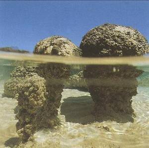
Ediacaran seas [2]. They were descendants of the lucky survivors of global glaciation during the preceding geological era. Since the Ediacarian the global ocean stayed open and is prospering with life.  However sea-life flourished since billion of years. Stromatolites populated freshwater of inland seas and coastal marine environments long time ago and still today. Different varieties of chlorophyta (green algae), bacteria and other unicellular marine algae, Acritarchs, prospered in the Proterozoic eon and were preserved as micro-fossil in marine sediments [3]. Many of these species were living on sulphur chemistry in an oxygen-poor sea through the billion years of the Proterozoic eon, including too a period  that geologist like to call the "boring billion" [4], although certainly it was full of unknown adventures of evolution of life.  

Cyanobacterial (Earth’s earliest oxygenic organisms)
stromatolites from Sharks Bay, Australia
The  Neoproterozoic era - meaning "recent era of early life" - was a dramatic time [5]. Twice Earth was ice-covered and was looking more like a ball of slush or snow. Twice Earth was sweating in  run-away greenhouse grilling the barren land. Life in the sea went through big swings.

Carbon isotope records in carbonate rocks  and Neoproterozoic glacial deposits found in Namibia suggest that biological productivity in the surface ocean collapsed for millions of years. Thus life faced a dramatic bottleneck after nearly three billion years of evolution of multiple forms using either chemical process (chemotrophic) or light (phototrophic) as source of energy. Geological findings show that marine ice extended from the Poles to the Equator at least twice during the Neoproterozoic era.

It is a teasing question whether open water was found along the Equator during that periods. How would phototrophic life survive when the entire planet, land and seas, are covered by ice?

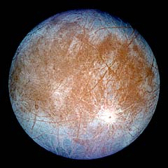
The  kilometre-thick layer of ice of the  Neoproterozoic ice-age made Earth looking like Jupiter's icy moon Europa. "Snowball Earth" looked far different from the blue ball that fascinated so much the first astronauts. However the global ocean kept active under the global ice cover. Survival of phototrophic life in a Snowball Earth climate possibly depended, as outcome of a  recent study [*] can be interpreted, on the ocean circulation and mixing processes that kept local patches of water open and thus created "marine heavens" in which  phototrophic life could survive.

Ocean circulation and mixing processes  set the melting and freezing rates of the  "marine glaciers" today and in the  Neoproterozoic era; the same physics apply. The melting and freezing rates determine ice-extend and the local ice thickness. Modern computer models of ocean circulation and ice-dynamics can simulate the physical behaviour of the global ocean of "Snowball Earth" and addressing too the question where to look for patches of open water for survival of phototrophic species.

from: http://truthaholics.wordpress.com/2013/03/06/
neoproterozoic-era-evidence-oceans-flowed-
on-snowball-earth/
The ocean of "Snowball Earth" was not freezing to the bottom. Salinity of seawater, high pressure and geothermal heat-flux from the bottom prevented that. The ocean is insulated at the surface from atmospheric forcing by the thick ice cover.  This ice-cover also is a very good thermal isolator preventing heat loss from the ocean. These features make up the very particular ocean dynamics of  "Snowball Earth". Water flows are driven by heat-flux from the sea-bottom and freezing at the surface. That is limiting vertical stratification. Today wind, radiation of the sun and evaporation drive the ocean currents from the surface and create a stable stratification of the water column. Geothermal heat-flux from the sea-bottom has not stopped, but its impact on the ocean dynamics is much less than the forces acting at the surface.  

A recent study [*], modelling dynamics of the Neoproterozoic ocean, highlights the processes that could maintain spots of open water (or thin ice) that phototrophic forms of life need for survival at the ice-margin. Today marine life prospers at the margin of sea-ice because of the particular dynamics of ice water interactions. Likewise life dwells at the bottom of sea-ice as long as some light penetrates through the ice. It is a teasing hypotheses that similar "marine heavens" were found in the ice-covered Neoproterozoic ocean.

Modern Earth: Geothermal heat-flux
The Neoproterozoic ocean of "Snowball Earth" is isolated at the surface by a kilometre-thick ice-layer. This layer cuts off effectively wind, solar radiation, evaporation and radiation losses.  Water freezing at the bottom of the "marine glaciers" and the heating of water at the sea bottom are the dominating processes, which drive water flows. Vertical convective mixing occurs. Water gets warmed at the sea-bottom by geothermal heat and rises towards the surface. Salt is leaking out of the water freezing to ice at the bottom of the marine glaciers. Adding salt to the cooled water is making it heavier so that it sinks towards the bottom. Therefore the ice-covered Neoproterozoic ocean is less stratified and properties of water, such as salinity vary with latitude. Lateral differences are maintained by the Coriolis-force [6] and related currents. Thus, in the Neoproterozoic ocean, close to the equator warmer and less-salty water rises to the surface, moving poleward and is sinking down again when cooled and enriched in salt-content. Similar overturning circulation cells are found in modern oceans but away from the equatorial zone.

The ocean temperature, salinity and density of  Neoproterozoic ocean was fairly uniform in the vertical direction but showed lateral differences. These lateral differences of density sustained, because of the rotation of earth, jet-currents along the Equator. These currents were unstable and were shedding off eddies. These eddies transported warm water away from the Equator to the ice-margin. There the water was melting ice, was cooled, partly frozen to the ice, partly enriched in salt  so that it sunk downward. A compensating upward flow of warm water occurred at the Equator to close the circulation cell. Ridges at the sea-bottom or continental margins brought the source of heat closer to the surface and were interacting with the equatorial jet-currents. This interaction caused local jets, eddies, coastal up-welling and down-welling as well as convective mixing . The weak stratification made up-welling and down-welling far easier to happen than today in our well stratified ocean. Thus "Snowball Earth" ocean was not a stagnant pool of cold water, it was highly dynamic; at least to the eye of the oceanographer.  

from [*]: Temperature at 1,200 m depth (colour scale), areas of enhanced geothermal heating (black contour lines) and land masses (white areas). b, Salinity at 1,200 m (colour scale). c, Ice thickness (colour scale), and ice velocity vectors 
These insights in dynamics of the Neoproterozoic ocean were  gained recently by computer simulations using models that couples ice flow and ocean circulation; and as the authors summarize [*]: "Compared with the modern ocean, the Snowball Earth ocean had far larger vertical mixing rates, and comparable horizontal mixing by ocean eddies. The strong circulation and coastal up-welling resulted in melting rates near continents as much as ten times larger than previously estimated."

And marine life? It survived "Snowball Earth". Both, the chemotrophic life that is using sulphur as source of energy and the phototrophic life that is using light as source of energy. Chemotrophic life would have survived in the depth of ocean under total ice-cover, but  phototrophic life would have needed patches open surface water or thin ice; at least temporarily. The physics of  ocean dynamics make it likely that these patches, "marine heavens" existed regularly in the ice-covered Neoproterozoic equatorial seas.

The geochemical carbon cycle on a Snowball Earth
http://www.learner.org/courses/envsci/unit/
text.php?unit=1&secNum=5
An essential prerequisite for existence of these "marine heavens" is that geothermal heat-flux through the sea-bottom was bigger as heat loss through the layer of marine glaciers at the surface. This ice-layer was moved and cracked by tides (as for example satellite pictures from Jupiter's moon Europa show for its ice-cover) and therefore the very thick ice-layer was not a perfect isolator. Heat will have been lost through the ice-cover.  Further studies of ice-dynamics may constrain what minimum geothermal heat-flux is needed to keep patches of  the Neoproterozoic ocean ice-free where ocean dynamics causes heat to be accumulated. Geophysical research then may assess whether this geothermal heat-flux is likely to have happened.

The end of  Snowball Earth likely was caused by volcanism blowing carbon-dioxide into the very dry and cold atmosphere of that time [7].  Rain must have been seldom, and without rain little carbon-acid weathering of rocks occurs and no carbonates are flushed into the sea. Thus carbon-dioxide accumulates in the atmosphere building up a greenhouse effect that finally caused Earth to warm again.

see:  http://www.seasky.org/
solar-system/jupiter-europa.html
If that scenario to end "Snowball Earth" happened, then Earth was saved from staying frozen in snowball stage by  its active geophysical processes. To note the difference, Jupiter's moon Europa is frozen in snowball stage; likely the moon is too small for having an active geophysical evolution as planet Earth. However, researchers are quite certain that under the icy surface of moon Europa an ocean is alive. If it bears life we don't now. But if, then it will be of a chemotrophic form. Luckily survival of phototophic life on Earth in the global glaciations of the  Neoproterozoic era has happened and likely because ocean dynamics on a geophysical active planet with continents moving, plate-tectonics and a robust geothermal heat-flux created some "marine heavens".

Martin.Mundusmaris@gmail.com
info@mundusmaris.org


[*]  Dynamics of a Snowball Earth ocean; Yosef Ashkenazy, Hezi Gildor, Martin Losch, Francis A. Macdonald, Daniel P. Schrag & Eli Tziperman; Nature 495, 90–93, 7th March 2013 March 2013

[1] for a debate about life on land see: http://www.nature.com/nature/journal/v493/n7430/full/nature11777.html

[2] from Wikipedia (simplified):  (a) The Ediacaran Period  named after the Ediacara Hills of South Australia, is the last geological period of the Neoproterozoic Era and of the Proterozoic Eon, immediately preceding the Cambrian Period. Its status as an official geological period was ratified in 2004 by the International Union of Geological Sciences (IUGS).  Although the Period takes its name from the Ediacara Hills where geologist Reg Sprigg first discovered fossils of the eponymous biota in 1946, the type section is located in the bed of the Enorama Creek within Brachina Gorge in the Flinders Ranges of South Australia, at 31°19′53.8″S 138°38′0.1″E. (b)  The Ediacara biota consisted of enigmatic tubular and frond-shaped, mostly sessile organisms. Trace fossils of these organisms have been found worldwide, and represent the earliest known complex multicellular organisms. The Ediacara biota radiated in an event called the Avalon Explosion, 575 million years ago, after the Earth had thawed from the Cryogenian period's extensive glaciation [and] disappeared contemporaneously with the rapid appearance of  Cambrian biota [which] completely replaced the organisms that populated the Ediacaran fossil record.

[3] from Wikipedia (simplified) Acritarchs have been recovered from sediments deposited as long as 3.2 billion years ago, but at about 1 billion years ago they started to increase in abundance, diversity, size, complexity of shape and especially size and number of spines. Their populations crashed during the Snowball Earth episodes, when all or very nearly all of the Earth's surface was covered by ice or snow, but they proliferated in the Cambrian explosion and reached their highest diversity in the Paleozoic. The increased spininess 1 billion years ago possibly resulted from the need for defence against predators, especially predators large enough to swallow them or tear them apart. Other groups of small organisms from the Neoproterozoic era also show signs of anti-predator defences. Further evidence that acritarchs were subject to herbivory around this time comes from a consideration of taxon longevity. The abundance of planktonic organisms that evolved between 1,700 and 1,400 million years ago was limited by nutrient availability – a situation which limits the origination of new species because the existing organisms are so specialised to their niches, and no other niches are available for occupation. Approximately 1,000 million years ago, species longevity fell sharply, suggesting that predation pressure, probably by protist herbivores, became an important factor. Predation would have kept populations in check, meaning that some nutrients were left unused, and new niches were available for new species to occupy.

[4] http://discovermagazine.com/2011/evolution/23-what-happened-earth-boring-billion-years#.UUlcMzsWm0c 

[5]  from Wikipedia (simplified): The Neoproterozoic Era is the unit of geologic time from 1,000 to 541 million years ago. The terminal Era of the formal Proterozoic Eon (or the informal "Precambrian"), it is further subdivided into the Tonian, Cryogenian, and Ediacaran Periods. The most severe glaciation known in the geologic record occurred during the Cryogenian, when ice sheets reached the equator and formed a possible "Snowball Earth". The earliest fossils of multicellular life are found in the Ediacaran, including the earliest animals.

[6]   from Wikipedia (modified):  Coriolis force: A force exerted on a parcel of water (or any moving body) due to the rotation of the earth. This force causes a deflection of the body to the right in the northern hemisphere and to the left in the southern hemisphere.

[7] from http://essayweb.net/geology/timeline/neoproterozoic.shtml (modified): The snowball Earth scenario does not require glaciation of the continents . The ice cover on the oceans prevented water from evaporating, and therefore the climate must have been very dry. Lack of precipitation likely caused at least parts of continents to be bare rock, as ice was sublimated or flowed into the sea, and was not replaced due to the lack of precipitation.  The commonly proposed scenario for the end of snowball Earth is through the accumulation of carbon dioxide. Volcanism produces carbon dioxide, which accumulates until it reaches a point where it triggers warming through its greenhouse effect. The ice sheets are melted rapidly and temperatures rise, perhaps reaching as high at 50 °C temporarily, before the carbon dioxide is removed from the atmosphere. There is strong evidence of such extreme rises in atmospheric carbon dioxide, in the form of cap carbonates.


Monday 4 February 2013

Change the pitch with a pinch of salt

The global balance of salinity of sea water is about stable. It is balanced by run-off from continents, evaporation, precipitation as well as inflow from hydrothermal vents and other interactions with the lithosphere. Salinity of different oceans and seas vary a bit reflecting mainly the regional balance of evaporation and run-off. Salinity of sea-water varies typically between 33 grams  and 37 grams per litre with a typical household average value of 35 grams per litre. However particular seas, like the Baltic Sea may deviate much from average salinity. Salinity of the open ocean is neither homogeneous nor fixed, and small variations are important for ocean dynamics and water flows. 

Surface salinity - see: Asian run-off, Arctic run-off etc.
[**]
Small variations of salinity are a markers for water-masses in the ocean, and tell us much about origin of these waters, their path and their fate. Early oceanographic research from the beginning of the 20th century discovered that already: The relative high salinity [1] of the North-Atlantic Ocean stems from waters of the Mediterranean Sea. 

Through the Straits of Gibraltar flows a mighty bottom current of very salty water [2] that is formed by the high evaporation in the eastern Mediterranean Sea. The  outflow at the bottom of the Gibraltar Strait is balanced by a surface flow of less saline waters of the North-Atlantic Ocean into the Mediterranean Sea. The relatively salty waters of the North-Atlantic move northward through the eastern North Atlantic touching on their westward flank relatively fresher waters flowing out of the Arctic Ocean. The mighty Siberian rivers discharge into the Arctic Ocean and cause a freshening of its surface waters. The high salinity of the North-Atlantic surface water is a key-parameter for the formation of  deep water in the Greenland Sea when sea-ice is formed in the fresher surface waters.

Deposits formed as Mediterranean was drying up
[***]
Throughout geological times salinity of the ocean varied reflecting geological or climatic change. A dramatic feature known for the Mediterranean Sea was its drying out a bit more than 5 Million years ago, in the so called “Messinian salinity crisis”, when the Strait of Gibraltar was closed - followed by the "Zanclean flood" once the straits opened again. Beyond such very dramatic events on a geological time scale, slight variations of sea-water salinity are a habitual play in the oceans. They are part of the “marine weather” below the surface. They are less well known to the general public than the known salinity changes in coastal zones in response to modified river run-off caused by human activity such as building the Assuan Dam on the Nile or water withdraw from the Colorado river or from China's big rivers. Human activity modifying the "marine weather" in the ocean would be of an impact of a higher magnitude than local changes of continental run-off. 

Inflow, evaporation and outflow
[#]
That anthropogenic climate change impacts on the physics and chemistry of the global ocean is established: rising sea-surface temperatures or climbing sea levels and ocean acidification by the absorption of excess carbon-dioxide  are known features.  They are not, however, the only potentially important shifts observed over recent decades. Drawing on observations from 1955 to 2004, [researchers] found that oceans' salinity changed throughout the study period, that changes were independent of known natural variability, and that shifts were consistent with the expected effects of anthropogenic climate change.” [*] This conclusion was drawn recently from studying salinity in the top 700m of the global ocean between 60°N and 60°S. 

A suite of computer models of the general water circulation in the ocean and atmosphere was used to assess the salinity changes that were shown in the observations since 1955. It came evident that the known natural cycles could not explain the observations. However the observed changes were consistent with what anthropogenic climate change should cause by shifting the hydrological cycle of evaporation, precipitation and run-off from continents. Theoretically, that is little surprising because higher sea-surface temperatures leading to higher heat content should modify evaporation and thus influence the global water cycle, and so in turn the salinity of the sea-water. However, that this impact can be tracked in changing salinities is new. At least I would have guessed that any impact cannot be discerned from the natural variability. 

Various estimate of ocean heat content in surface layer
[****]
Thus we might now conclude: salinity of sea water is balanced by run-off from continents, evaporation, inflow from hydrothermal vents and other interactions with the lithosphere. But that recently human-induced climate change has  started to influence this balance. Human activity being a noticeable co-driver of hydrological cycles up to shifting salinity of the world ocean, a bit along the line of action: ...increase Greenhouse gases, increase sea-surface temperatures and heat-content, modify hydrological cycles and shift salinities of sea-water...


Martin.Mundusmaris@gmail.com
info@mundusmaris.org


[1] of about 36.5 grams per litre sea-water
[2] of about 38.5 grams per litre sea-water
[*] quote from: “Global ocean salinity changing due to anthropogenic climate change”, EOS, Transaction of the American Geophysical Union, Vol. 94(5) p.60 2013; reporting on research of Pierce et al. "The fingerprint of human-induced changes in the ocean's salinity and temperature fields" published in Geophysical Research Letters 39(21) 2012.
[**] http://www.sciencebuddies.org/science-fair-projects/project_ideas/OceanSci_p002.shtml
[***] http://records.viu.ca/~earles/messinian-crisis-apr03.htm
[#] from not identified source, picture found by Google  - the presentation is incomplete: (1) the out-flowing waters turn north flowing along continental margin, (2) the flow is structured by eddies that are spinning of to migrate south-westward 
[****] from: http://www.aip.org/history/climate/20ctrend.htm